
Counting dolphins.... It takes a village
- Claire Lacey

- Feb 5, 2024
- 3 min read
By Claire Lacey
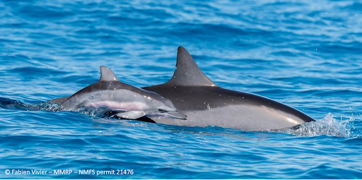
If you pick up almost any ecology or wildlife conservation textbook, you won’t have to read many pages before you’ll find a sentence that reads something like: “a knowledge of the abundance and distribution of animals is key to assess conservation status”. In other words – if we don’t know how many of a species there are, or where they live, it is very difficult to protect them effectively. Regular blog readers will know that since starting at MMRP in 2021, I’ve been working to obtain this information for the spinner dolphins that use the habitat around O’ahu, Big Island, and ultimately, Maui Nui (If you’re new to the blog and want to read some more about the background to this work – you can find some more info here: Intro to counting dolphins, Big Island fieldwork & photo ID). Unfortunately, for many species – including most dolphin and whale species – getting this information is not always easy and can take a long time - involving many days in the field, and even more processing data.
To give some idea of the scale of the fieldwork completed so far, here are some stats for you:
Fieldwork stats: Oahu – completed using small boats:
Days on the water: 72
Total distance covered: ~7600km
Amount of survey distance covered: ~3100 km
Boats used: 5
Organizations involved: 2
Volunteers involved: 61
Cetacean species seen: 5
Spinner dolphin groups encountered: 85
Photos taken: approx: ~50,000
Undergraduate projects completed using data from these surveys: 4 - from 4 different universities

Completed survey effort - using small boats - around the island of O'ahu
Fieldwork stats: Big Island – completed using small boats on the west side and small planes around the rest of the island:
Days on the water - boats: 50
Days in the air – planes: 9
Total distance covered: ~29440 km
Amount of survey distance covered (boat): ~3200 km
Amount of survey distance covered (plane): ~7100 km
Boats used: 2
Planes used: 1
Organizations involved: 4
Volunteers involved: 40
Cetacean species seen - boats: 11
Cetacean species seen – planes: 8
Spinner dolphin groups encountered - boats: 76
Spinner dolphin groups encountered - planes: 19
Photos taken: approx. ~90,000
Undergraduate projects completed using data from these surveys: 3 - from 3 different universities

Completed survey effort - using small boats (black) and planes (blue) - around the island of O'ahu
This scale of operation is a massive collaborative effort as you can probably tell from the numbers above. The main project funding came from NOAA / PIFSC, who also participated in some of the surveys of O'ahu. Aerial surveys were a collaboration between us here at MMRP, and teams from HAMER and UH Hilo. Big Island vessels surveys were conducted by MMRP, but with boats and Captains from Captain Zodiac; and none of this work would have been possible without the incredibly dedicated team of interns and volunteers who were integral to both data collection and helping with the data processing after the surveys.
It takes a while to process a dataset this size, which is why you've not heard much from us for a while. Things are progressing nicely though, so stay tuned for some updates in the near future!
In terms of surveys on other islands, we're partnering with Pacific Whale Foundation to survey the waters around Maui, Lanai, Moloka'i and Kaho'olawe (collectively known as Maui Nui) and the PWF team started data collection in late 2023. Updates on this will follow when we have them too! Exciting times, abundance fans...


Escape Road 3 is a fantastic browser game with exciting police chases, fast cars, and challenging gameplay mechanics. The action never slows down, making every run feel thrilling and competitive. It’s a must-play online game for fans of racing and escape games!